
Interfase-UAB has participated in the ESPON seminar focused on ‘Transforming Territorial Thinking Through Digitalisation”, representing two ongoing projects: ESPON 2020 Database Portal and ESPON GRETA. Continue reading “Interfase-UAB participates in the ESPON seminar ‘Transforming Territorial Thinking Through Digitalisation””
Category: Territorial sustainability & spatial restructuring
Land recycling in Europe
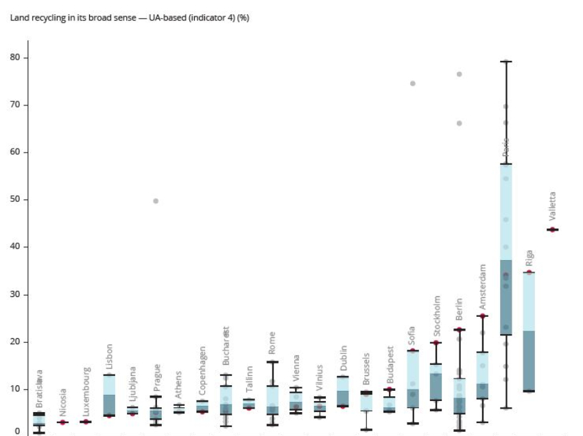
The EEA has recently published a report entitled “Land recycling in Europe“, which presents approaches to measuring the extent and impacts of redevelopment and densification of previously developed land. Continue reading “Land recycling in Europe”
Copernicus Land: improving the road network within Functional Urban Areas
The European Copernicus programme, previously known as Global Monitoring for Environment and Security (GMES) is an EU-wide programme that aims to support policymakers, business, and citizens with improved environmental information. Copernicus integrates satellite and in-situ data with modeling to provide user-focused information services.
UAB is leading the Copernicus task EEA/IDM/15/010 under the ETC-ULS consortium including partners from Luxembourg (Space4Environment) and Hungary (FÖMI).
The aim and name of the task is to “Assess the completeness, up to datedness and accessibility to existing road network databases within a selection of Functional Urban Areas of Urban Atlas 2012.” Continue reading “Copernicus Land: improving the road network within Functional Urban Areas”